Understanding the Requirements Behind Modern Traffic Control Plan Reviews
If you’ve submitted Traffic Control Plans (TCPs) in multiple jurisdictions, you’ve probably noticed that permit requirements can vary significantly from one agency to another. While some municipalities and transportation departments prefer traditional drafted plans based on engineering drawings, others increasingly require TCPs to be developed using current satellite imagery or aerial photography.
For contractors, utility companies, telecommunications providers, and infrastructure developers, understanding these requirements can save valuable time during the permitting process and help avoid costly revisions.
What Is the Difference Between a Traditional Drafted TCP and a Satellite-Based TCP?
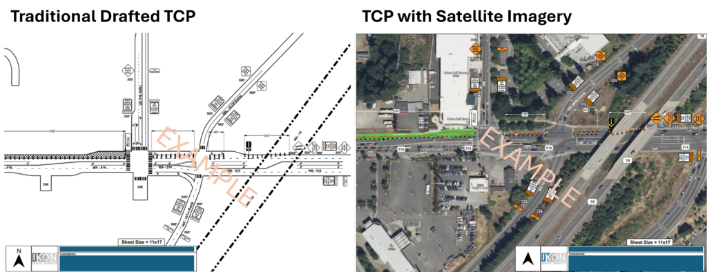
A traditional Traffic Control Plan typically shows roadways, lanes, intersections, signs, and work areas using engineering-style line drawings. These plans focus on dimensions, traffic control devices, and work zone layouts while maintaining consistency with MUTCD standards.
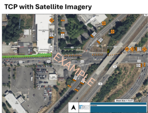
A satellite-based TCP uses recent aerial imagery as the base map. Traffic control devices, closure limits, detours, pedestrian routes, and work zones are then overlaid directly onto the image.
Both formats can effectively communicate temporary traffic control requirements. The preferred format often depends on the reviewing agency’s goals and the characteristics of the project.
Why Some Jurisdictions Require Satellite Imagery
1. Improved Understanding of Existing Conditions
One of the biggest advantages of satellite imagery is that reviewers can immediately see actual field conditions.
Features such as:
- Existing driveways
- Sidewalks and pedestrian ramps
- Median islands
- Bus stops
- Landscaping features
- Adjacent businesses
- School zones
are often visible without requiring reviewers to cross-reference additional plans or GIS systems.
For complex urban environments along Colorado’s Front Range, this visual context can help agencies evaluate how a closure will impact both motorists and pedestrians.
2. Faster Permit Reviews
Permit reviewers often manage dozens of TCP submissions each week. Satellite imagery allows reviewers to quickly orient themselves and understand exactly where work will occur.
Instead of interpreting a simplified roadway drawing, reviewers can see the actual intersection, roadway geometry, and surrounding environment immediately.
This often reduces clarification requests and revision cycles.
3. Better Representation of Temporary Conditions
Roadway conditions can change faster than engineering base maps are updated.
New developments, recently installed sidewalks, temporary barriers, or modified lane configurations may not appear on older drawings. Recent aerial imagery can provide a more accurate representation of existing conditions, helping agencies identify potential conflicts before construction begins.
4. Enhanced Coordination Between Stakeholders
Traffic control plans are reviewed by more than just traffic engineers.
Project managers, inspectors, law enforcement personnel, public works staff, utility representatives, and construction supervisors may all reference the same TCP.
Satellite imagery is often easier for non-technical stakeholders to understand because it resembles what they see in the field.
5. Increased Focus on Pedestrian and ADA Considerations
Many jurisdictions are placing greater emphasis on pedestrian access and ADA compliance during construction activities.
Aerial imagery can help reviewers evaluate:
- Sidewalk closures
- Pedestrian detours
- Temporary crossings
- Transit stop impacts
- Accessibility routes
This additional context helps agencies verify that all roadway users have been considered during project planning.
Why Other Jurisdictions Still Prefer Traditional Drafted Plans
Despite the benefits of satellite imagery, many agencies continue to require traditional drafted TCPs.
Standardization
Drafted plans provide a consistent format that reviewers are familiar with. This consistency can simplify reviews for routine projects and recurring work activities.
Greater Design Precision
Projects involving multiple phases, detailed lane shifts, long-term traffic control, or complex detour routes often benefit from engineering-style drawings that clearly communicate dimensions and device spacing.
Easier Plan Integration
Many agencies incorporate TCPs into larger plan sets that include utility, civil, and roadway drawings. Traditional drafted plans often integrate more seamlessly with these engineering documents.
The Best Approach: Matching the Jurisdiction’s Expectations
There is no universal “best” format for every project.
The most effective Traffic Control Plan is the one that satisfies agency requirements while clearly communicating how traffic, pedestrians, cyclists, and adjacent properties will be accommodated during construction.
In many cases, agencies are moving toward hybrid approaches that combine traditional traffic control layouts with aerial imagery backgrounds to provide both technical accuracy and real-world context.
Understanding these preferences before submitting a permit application can help avoid delays, reduce revisions, and keep projects on schedule.
Working with an Experienced TCP Provider
Because requirements vary between municipalities, counties, state agencies, and transportation departments, it’s important to work with a TCP provider familiar with jurisdiction-specific expectations.
At Ikon Traffic, we develop permit-ready Traffic Control Plans using the format preferred by the reviewing agency—whether that means traditional drafted plans, satellite-based TCPs, or a hybrid approach. Our team helps contractors and infrastructure providers navigate permitting requirements throughout Colorado and across the Mountain West.
Ready to get your project moving? Contact Ikon Traffic to discuss your traffic control planning needs: https://ikontraffic.com/contact/